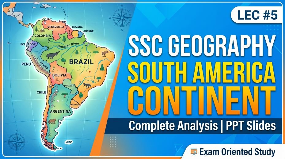
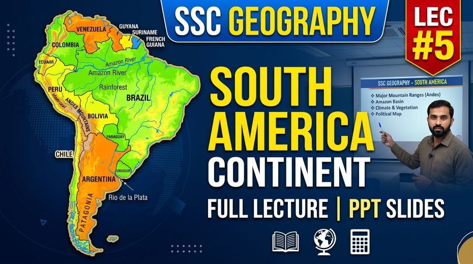
This article accompanies the SSC Geography South America Continent PPT Slides (LEC #5) – Serial #83 of the Complete Foundation Batch for All SSC Exams PPT Series on slideshareppt.net. With 94 slides in bilingual Hindi + English format, this PPT covers South America in complete depth. South America is home to the world’s largest rainforest, the longest mountain range, and the driest non-polar desert on Earth – making it one of the most fact-dense and frequently tested continents in SSC CGL, SSC CHSL, SSC MTS, SSC GD Constable, and RRB Group D General Awareness sections. From the Amazon Rainforest and Andes Mountains to Angel Falls and Lake Titicaca, South America offers an enormous range of high-yield geography facts so, this article provides the full structured theory, timeline, comparison tables, MCQs, and a rapid revision cheat sheet – all aligned to the SSC exam pattern.
PPT Resource Overview
| Detail | Information |
| Lecture Number | LEC #5 (Geography Series) |
| Serial Number in Complete Batch | #83 |
| Subject | Geography – South America Continent (दक्षिण अमेरिका महाद्वीप) |
| Series Name | Complete Foundation Batch for All SSC Exams (PPT Series) |
| Total Slides | 94 PPT Slides |
| File Size | 25 MB |
| Language | Hindi + English (Bilingual) |
| Format Available | Google Slides & Google Drive (PDF also available) |
| Website | www.slideshareppt.net |
| Target Exams | SSC CGL, SSC CHSL, SSC MTS, SSC GD Constable, RRB Group D |
| Suitable For | Students (self-study & marathon revision) and Teachers (classroom use) |
SSC Geography South America Continent PPT Slides (LEC #5)
Note: Above is PPT in GOOGLE SLIDES (HTML AND IFRAME COMBINATION) and if you wish to download the Complete SSC series (PPT slides), visit this Link – REDIRECT PAGE.
Master Timeline: South America – Civilisations, Colonisation, and Independence
| Period | Event / Milestone | SSC Exam Relevance |
| ~3500 BCE | Early Andean civilisations emerge in present-day Peru – among oldest in the Americas | Origin of South American civilisation |
| ~1200 CE | Rise of the Inca Empire in the Andes, centred near Cusco, Peru | Inca Empire – major pre-Columbian civilisation |
| 1438–1533 | Inca Empire reaches its peak – largest empire in pre-Columbian America, spanning the Andes | Inca Empire’s territorial extent |
| 1494 | Treaty of Tordesillas divides South America between Spain and Portugal | Spanish vs Portuguese colonial division – frequently asked |
| 1500 | Pedro Álvares Cabral (Portugal) lands in Brazil – beginning of Portuguese colonisation | Origin of Brazil’s Portuguese heritage |
| 1532 | Francisco Pizarro (Spain) captures Inca Emperor Atahualpa – beginning of fall of Inca Empire | Fall of Inca Empire to Spanish conquest |
| 1533 | Inca Empire effectively ends with Spanish conquest of Cusco | End of major pre-Columbian civilisation |
| 1600s–1700s | Spanish and Portuguese colonial rule consolidates across most of South America | Colonial period of South America |
| 1808–1826 | Wars of independence sweep across South America led by Simon Bolivar and Jose de San Martin | South American independence movements |
| 1816 | Argentina declares independence from Spain | Argentina’s independence |
| 1818 | Chile declares independence under Bernardo O’Higgins | Chile’s independence |
| 1819 | Simon Bolivar leads creation of Gran Colombia (later split into Colombia, Venezuela, Ecuador, Panama) | Bolivar’s role in independence – very frequently asked |
| 1822 | Brazil declares independence from Portugal, becomes an Empire under Pedro I | Brazil’s unique path to independence (as an empire) |
| 1824 | Battle of Ayacucho – decisive victory ends Spanish colonial rule in South America | End of Spanish rule in South America |
| 1889 | Brazil becomes a republic, ending the Brazilian Empire | Brazil’s transition to republic |
| 1914 | Panama Canal opens (technically Central America, but reshapes South American trade routes) | Major infrastructure affecting South American trade |
| Present Day | South America comprises 12 sovereign countries plus French Guiana (French overseas territory) | Current political map of South America |
South America – Overview of the Continent
South America is the fourth-largest continent by area and the fifth most populous. It is connected to North America via the Isthmus of Panama and is bordered by the Pacific Ocean to the west and the Atlantic Ocean to the east. The continent is home to the Amazon Rainforest (the world’s largest tropical rainforest), the Andes (the world’s longest continental mountain range), and the Amazon River (the largest river by discharge volume on Earth).
South America – Complete Key Facts Table
| Parameter | Detail |
| Continent Rank by Area | 4th largest continent (after Asia, Africa, North America) |
| Total Area | 17.8 million sq km |
| Population (approx.) | ~436 million |
| Number of Countries | 12 sovereign countries + French Guiana (French overseas territory) |
| Largest Country by Area | Brazil (8.5 million sq km) |
| Smallest Country by Area | Suriname |
| Most Populous Country | Brazil (~216 million) |
| Highest Peak | Aconcagua – 6,961 m (Argentina) – highest peak outside Asia |
| Longest River | Amazon River – ~6,400 km (2nd longest in world after Nile, but largest by discharge) |
| Largest Rainforest | Amazon Rainforest – ~5.5 million sq km, spans 9 countries |
| Largest Lake (navigable) | Lake Titicaca – highest large lake in the world (3,812 m elevation), shared by Peru and Bolivia |
| Driest Place on Earth | Atacama Desert (Chile) – some areas have not seen rain in centuries |
| Highest Waterfall | Angel Falls – 979 m (Venezuela), world’s highest uninterrupted waterfall |
| Largest Waterfall (by volume/width) | Iguazu Falls – on Brazil-Argentina border, wider than Niagara Falls |
| Major Mountain Range | The Andes – world’s longest continental mountain range (~7,000 km) |
| Languages | Spanish (most countries), Portuguese (Brazil), Dutch (Suriname), English (Guyana), French (French Guiana) |
| Religion (majority) | Roman Catholic Christianity (largest Catholic population of any continent) |
| Equator Passes Through | Ecuador, Colombia, Brazil |
| Tropic of Capricorn Passes Through | Chile, Argentina, Paraguay, Brazil |
| Time Zones | Multiple – ranging from GMT−2 to GMT−5 |
Countries of South America – Complete Reference Table
| Country | Capital | Official Language | Key Geographic Fact |
| Brazil | Brasília | Portuguese | Largest country in South America; contains ~60% of Amazon Rainforest; only Portuguese-speaking country in the Americas |
| Argentina | Buenos Aires | Spanish | 2nd largest country; home to Patagonia and Aconcagua (highest peak in Americas) |
| Peru | Lima | Spanish (also Quechua, Aymara) | Former heart of the Inca Empire; Machu Picchu; shares Lake Titicaca with Bolivia |
| Colombia | Bogotá | Spanish | Only South American country with coastlines on both Pacific and Caribbean (Atlantic) |
| Venezuela | Caracas | Spanish | Home to Angel Falls – world’s highest waterfall; large oil reserves |
| Chile | Santiago | Spanish | Longest north-south country in the world (~4,300 km); contains Atacama Desert |
| Ecuador | Quito | Spanish | Named after the Equator, which passes through it; Galápagos Islands belong to Ecuador |
| Bolivia | La Paz (administrative) / Sucre (constitutional) | Spanish (also Quechua, Aymara) | Landlocked country; shares Lake Titicaca with Peru; has two capitals |
| Paraguay | Asunción | Spanish, Guarani | Landlocked; one of only two landlocked countries in South America |
| Uruguay | Montevideo | Spanish | One of the smallest countries in South America; high standard of living |
| Guyana | Georgetown | English | Only English-speaking country in South America |
| Suriname | Paramaribo | Dutch | Smallest sovereign country in South America; only Dutch-speaking country in the Americas |
| French Guiana | Cayenne | French | Overseas territory of France, not an independent country; uses the Euro |
Physical Geography of South America
Mountains of South America
| Mountain Range / Peak | Location | Height / Length | Key Facts for SSC |
| The Andes | Western coast – runs through 7 countries | ~7,000 km long | World’s longest continental mountain range; separates narrow western coast from vast interior |
| Aconcagua | Argentina (Andes) | 6,961 m | Highest peak in South America and in the Western/Southern Hemisphere; part of the ‘Seven Summits’ |
| Ojos del Salado | Chile-Argentina border | 6,893 m | 2nd highest peak in South America and Western Hemisphere; world’s highest active volcano |
| Chimborazo | Ecuador | 6,263 m | Point on Earth’s surface farthest from Earth’s centre due to equatorial bulge |
| Cotopaxi | Ecuador | 5,897 m | One of the world’s highest active volcanoes |
Rivers of South America
| River | Length | Countries | Key Facts for SSC |
| Amazon River | ~6,400 km | Peru, Colombia, Brazil (mainly) | Largest river by discharge volume in the world; 2nd longest after the Nile (debated); drains ~7 million sq km basin; no bridges cross it |
| Paraná River | ~4,880 km | Brazil, Paraguay, Argentina | 2nd longest river in South America; forms part of Iguazu Falls system; major trade route |
| Madeira River | ~3,250 km | Bolivia, Brazil | Largest tributary of the Amazon by volume |
| São Francisco River | ~2,914 km | Brazil (entirely) | Known as ‘River of National Unity’ in Brazil – flows entirely within one country |
| Orinoco River | ~2,140 km | Venezuela, Colombia | One of the longest rivers in South America; forms vast Orinoco Delta |
| Uruguay River | ~1,838 km | Brazil, Argentina, Uruguay | Forms part of the border between Argentina and Uruguay |
Lakes, Deserts, and Natural Wonders
| Feature | Type | Location | Key SSC Facts |
| Lake Titicaca | Freshwater Lake | Peru-Bolivia border | Highest large navigable lake in the world (3,812 m elevation); sacred to Inca mythology; shared between two countries |
| Lake Maracaibo | Lake (connected to sea) | Venezuela | Largest lake in South America by area; rich in oil reserves; technically a bay/lake hybrid |
| Atacama Desert | Desert | Chile | Driest non-polar desert on Earth; some areas have never recorded rainfall; used to simulate Mars conditions |
| Patagonian Desert | Desert | Argentina, Chile | Largest desert in the Americas; cold desert in southern South America |
| Angel Falls | Waterfall | Venezuela (Canaima National Park) | World’s highest uninterrupted waterfall at 979 m; named after aviator Jimmie Angel |
| Iguazu Falls | Waterfall System | Brazil-Argentina border | Wider than Niagara Falls; consists of ~275 individual falls; UNESCO World Heritage Site |
| Amazon Rainforest | Tropical Rainforest | Spans 9 countries (mainly Brazil) | World’s largest tropical rainforest (~5.5 million sq km); called ‘lungs of the Earth’; produces ~20% of world’s oxygen (commonly cited figure, debated by scientists) |
| Galápagos Islands | Volcanic Islands | Ecuador (Pacific Ocean) | Inspired Charles Darwin’s theory of evolution; UNESCO World Heritage Site; unique endemic species |
Climate of South America
| Climate Zone | Region | Key Characteristics |
| Tropical Rainforest | Amazon Basin (Brazil, Peru, Colombia) | Heavy year-round rainfall; high humidity; consistently warm temperatures |
| Tropical Savanna | Brazilian Highlands, Llanos (Venezuela/Colombia) | Wet and dry seasons; grasslands with scattered trees |
| Desert / Arid | Atacama Desert (Chile), parts of Patagonia | Extremely low rainfall; Atacama is driest non-polar desert on Earth |
| Mediterranean | Central Chile | Hot dry summers, mild wet winters – similar to Mediterranean Europe |
| Temperate Oceanic | Southern Chile, parts of Argentina | Mild temperatures, year-round rainfall |
| Highland / Alpine | Andes Mountains (high altitude regions) | Cold temperatures regardless of latitude due to elevation; thin air |
| Steppe / Pampas Grassland | Argentina, Uruguay | Fertile temperate grasslands; major agricultural region (the Pampas) |
Wildlife of South America – SSC GK Facts
| Category | Key Species | SSC Fact |
| Mammals | Jaguar, Capybara, Giant Otter, Llama, Alpaca, Vicuña, Sloth | Capybara is world’s largest rodent; Llama and Alpaca domesticated by Inca civilisation in the Andes |
| Birds | Andean Condor, Macaw, Toucan, Hoatzin | Andean Condor has one of the largest wingspans of any land bird |
| Reptiles & Amphibians | Anaconda, Poison Dart Frog, Caiman | Green Anaconda is the heaviest snake in the world; found in Amazon Basin |
| Fish | Piranha, Arapaima | Arapaima is one of the largest freshwater fish in the world, found in the Amazon |
| Unique Ecosystem | Amazon Rainforest biodiversity | Contains an estimated 10% of all known species on Earth |
| Galápagos Species | Giant Tortoise, Marine Iguana, Galápagos Finch | Endemic to Galápagos Islands (Ecuador); central to Darwin’s theory of evolution |
The Inca Empire – Pre-Columbian Civilisation
| Parameter | Detail |
| Period | ~1438 to 1533 CE (peak); origins from ~1200 CE |
| Capital | Cusco, Peru |
| Famous Site | Machu Picchu – UNESCO World Heritage Site; ‘Lost City of the Incas’ |
| Extent | Stretched along the Andes from modern Colombia to Chile and Argentina |
| Achievements | Advanced road network (Inca Trail), agricultural terracing, stone architecture without mortar |
| Fall | Conquered by Spanish conquistador Francisco Pizarro in 1532–1533 |
| Legacy | Quechua language still spoken by millions in Peru, Bolivia, Ecuador |
South America Compared to All 7 Continents – Reference Table
| Continent | Area (sq km) | Population | Highest Point | Key Fact |
| Asia | 44.6 million | 4.7 billion | Mt. Everest (8,848 m) | Largest and most populous continent |
| Africa | 30.4 million | 1.4 billion | Mt. Kilimanjaro (5,895 m) | 2nd largest; Sahara Desert |
| North America | 24.7 million | 580 million | Denali (6,194 m) | 3rd largest; includes Greenland |
| South America | 17.8 million | ~436 million | Aconcagua (6,961 m) | 4th largest; Amazon Rainforest, Andes, Atacama Desert |
| Antarctica | 14.2 million | ~1,000 (researchers) | Vinson Massif (4,892 m) | 5th largest; no permanent population |
| Europe | 10.5 million | 746 million | Mont Blanc (4,808 m) | 6th largest; most developed |
| Australia | 7.7 million | ~26 million | Mt. Kosciuszko (2,228 m) | Smallest continent; only country-continent |
Quick Fact Table – South America for SSC Exams
| Question / Fact | Answer |
| South America’s rank by area among continents | 4th largest |
| South America’s total area | 17.8 million sq km |
| Number of countries in South America | 12 sovereign countries + French Guiana (territory) |
| Largest country in South America | Brazil |
| Smallest sovereign country in South America | Suriname |
| Highest peak in South America | Aconcagua (6,961 m) – Argentina |
| Longest river in South America | Amazon River (~6,400 km) |
| River with largest discharge volume in world | Amazon River |
| World’s largest tropical rainforest | Amazon Rainforest (~5.5 million sq km) |
| World’s highest uninterrupted waterfall | Angel Falls (979 m) – Venezuela |
| Waterfall wider than Niagara Falls | Iguazu Falls – Brazil-Argentina border |
| World’s longest continental mountain range | The Andes (~7,000 km) |
| Driest non-polar desert on Earth | Atacama Desert – Chile |
| Highest navigable lake in the world | Lake Titicaca – Peru-Bolivia border (3,812 m) |
| Only English-speaking country in South America | Guyana |
| Only Portuguese-speaking country in South America | Brazil |
| Only Dutch-speaking country in South America | Suriname |
| Capital of Brazil | Brasília |
| Capital city famous for tango and Spanish heritage | Buenos Aires, Argentina |
| Capital of Peru, former Inca heartland | Lima |
| Country named after the Equator | Ecuador |
| Famous Inca ruins / UNESCO site in Peru | Machu Picchu |
| Spanish conquistador who defeated the Inca Empire | Francisco Pizarro (1532–1533) |
| South American leader of independence movements | Simon Bolivar |
| Treaty dividing South America between Spain & Portugal | Treaty of Tordesillas (1494) |
| Country with two capitals (administrative & constitutional) | Bolivia – La Paz and Sucre |
| Islands that inspired Darwin’s theory of evolution | Galápagos Islands – Ecuador |
| Largest rodent in the world | Capybara – found in South America |
| Heaviest snake in the world | Green Anaconda – found in Amazon Basin |
| Landlocked countries in South America | Bolivia and Paraguay |
Podcast-Style Q&A – South America Continent
Q1: Why is the Amazon River considered the largest river in the world despite the Nile being longer?
The Amazon River is generally considered the longest river in some recent measurements (~6,992 km by certain studies), though traditionally the Nile (~6,650 km) has been listed as longest, making this a genuinely debated topic in geography. However, the Amazon is unambiguously the largest river in the world by discharge volume – it carries more water than the next seven largest rivers combined, discharging roughly 20% of all freshwater that enters the world’s oceans. This combination of immense volume and competitive length makes the Amazon a frequently tested fact in SSC exams, where both ‘longest’ and ‘largest by volume’ framings can appear.
Q2: What makes the Atacama Desert unique compared to other deserts?
The Atacama Desert in Chile is considered the driest non-polar desert on Earth. Some weather stations within the Atacama have never recorded measurable rainfall in documented history. This extreme dryness occurs because the desert lies between two mountain ranges (the Andes and the Chilean Coast Range) that block moisture from both the Pacific Ocean and the Amazon Basin, combined with the cold Humboldt Current offshore that suppresses rainfall. Because of its Mars-like landscape and clear night skies, the Atacama is used by scientists for astronomical observation and to simulate Martian conditions for space research.
Q3: Why did Spain and Portugal divide South America through the Treaty of Tordesillas?
In 1494, following the early voyages of Columbus, Spain and Portugal – the two dominant naval powers of the time – signed the Treaty of Tordesillas to avoid conflict over newly discovered lands. The treaty drew a north-south line roughly 370 leagues west of the Cape Verde Islands; lands to the east of this line went to Portugal, and lands to the west went to Spain. This is the direct historical reason why Brazil speaks Portuguese today while the rest of South America largely speaks Spanish – the treaty line passed through the eastern part of the continent, placing Brazil’s coast within Portugal’s zone.
Q4: What was the significance of the Inca Empire and how did it fall?
The Inca Empire, centred in Cusco, Peru, was the largest empire in pre-Columbian America, stretching along the Andes from modern Colombia to Chile and Argentina at its peak around 1438–1533. The Incas built an extensive road network, advanced agricultural terracing systems for farming on steep mountain slopes, and constructed remarkable stone architecture – including Machu Picchu – without using mortar. The empire fell rapidly after Spanish conquistador Francisco Pizarro captured the Inca Emperor Atahualpa in 1532, exploiting internal succession conflicts and using superior weaponry, leading to the empire’s collapse by 1533.
Q5: Why does Bolivia have two capital cities?
Bolivia has a unique constitutional arrangement with two capitals: Sucre is the constitutional and judicial capital, while La Paz serves as the administrative seat of government, housing the executive and legislative branches. This division dates back to a civil conflict in the early 20th century, after which government functions moved to La Paz while Sucre retained its status as the official constitutional capital. This dual-capital arrangement is a frequently asked SSC trivia fact, often confused with similarly unique capital arrangements elsewhere in the world.
Q6: What is the significance of the Galápagos Islands in scientific history?
The Galápagos Islands, belonging to Ecuador and located in the Pacific Ocean about 1,000 km off the coast, played a pivotal role in scientific history when Charles Darwin visited them in 1835 aboard HMS Beagle. Observing the unique adaptations of species like finches and giant tortoises across different islands, Darwin developed key insights that contributed to his theory of evolution by natural selection, published in ‘On the Origin of Species’ (1859). The islands remain a UNESCO World Heritage Site and are home to many endemic species found nowhere else on Earth.
Q7: Why is the Amazon Rainforest often called the ‘lungs of the Earth’?
The Amazon Rainforest, spanning approximately 5.5 million sq km across nine countries (primarily Brazil), is commonly called the ‘lungs of the Earth’ because of the enormous volume of oxygen its plant life produces and the carbon dioxide it absorbs through photosynthesis – though scientists note the rainforest’s net oxygen contribution to the atmosphere is debated, since much of the oxygen produced is also consumed by decomposition within the forest itself. Regardless of the exact oxygen calculation, the Amazon remains critically important for global climate regulation, carbon storage, and biodiversity, hosting an estimated 10% of all known species on Earth – making deforestation in the Amazon a major topic in both Geography and Environment sections of SSC exams.
30 MCQ Practice Questions – South America Continent
All questions follow SSC CGL, CHSL, MTS, and GD Constable exam patterns. Answers follow at the end.
- South America is the ___ largest continent by area.
A) 3rd B) 4th C) 5th D) 6th
- What is the largest country in South America by area?
A) Argentina B) Peru C) Brazil D) Colombia
- The capital of Brazil is:
A) Rio de Janeiro B) São Paulo C) Brasília D) Salvador
- Which is the highest peak in South America?
A) Chimborazo B) Aconcagua C) Cotopaxi D) Ojos del Salado
- The Amazon River is famous for being the largest river by:
A) Length B) Discharge volume C) Number of tributaries D) Width at mouth
- The world’s largest tropical rainforest is:
A) Congo Rainforest B) Amazon Rainforest C) Daintree Rainforest D) Sundarbans
- Angel Falls, the world’s highest waterfall, is located in:
A) Brazil B) Argentina C) Venezuela D) Peru
- Iguazu Falls is located on the border of which two countries?
A) Peru-Bolivia B) Brazil-Argentina C) Chile-Argentina D) Colombia-Venezuela
- The driest non-polar desert in the world is:
A) Sahara Desert B) Thar Desert C) Atacama Desert D) Gobi Desert
- Lake Titicaca is shared between which two countries?
A) Chile-Argentina B) Peru-Bolivia C) Brazil-Paraguay D) Colombia-Ecuador
- Which is the only English-speaking country in South America?
A) Suriname B) Guyana C) French Guiana D) Belize
- Which country is the only Portuguese-speaking nation in the Americas?
A) Argentina B) Brazil C) Chile D) Uruguay
- The Inca Empire’s capital was located at:
A) Lima B) Cusco C) Quito D) La Paz
- Who led the Spanish conquest that ended the Inca Empire?
A) Hernán Cortés B) Christopher Columbus C) Francisco Pizarro D) Ferdinand Magellan
- The Treaty of Tordesillas (1494) divided South America between:
A) Britain and France B) Spain and Portugal C) Netherlands and Spain D) Britain and Spain
- Which leader is most associated with South American independence movements?
A) Simon Bolivar B) George Washington C) Mahatma Gandhi D) Nelson Mandela
- Which country has two capital cities?
A) Peru B) Chile C) Bolivia D) Ecuador
- The Galápagos Islands belong to which country?
A) Peru B) Chile C) Colombia D) Ecuador
- Charles Darwin developed his theory of evolution after visiting:
A) Amazon Rainforest B) Galápagos Islands C) Atacama Desert D) Andes Mountains
- The world’s longest continental mountain range is:
A) Rockies B) Alps C) Andes D) Himalayas
- Which is the largest rodent in the world, found in South America?
A) Beaver B) Capybara C) Guinea Pig D) Porcupine
- The heaviest snake in the world, found in the Amazon, is the:
A) King Cobra B) Green Anaconda C) Python D) Black Mamba
- Which two South American countries are landlocked?
A) Brazil and Chile B) Bolivia and Paraguay C) Peru and Ecuador D) Argentina and Uruguay
- The Pampas grasslands are mainly located in:
A) Brazil and Peru B) Chile and Bolivia C) Argentina and Uruguay D) Venezuela and Colombia
- Which South American country is named after the Equator?
A) Colombia B) Ecuador C) Peru D) Bolivia
- Machu Picchu, a famous Inca site, is located in:
A) Bolivia B) Chile C) Peru D) Ecuador
- Which is the only Dutch-speaking country in South America?
A) Guyana B) French Guiana C) Suriname D) Venezuela
- Lake Maracaibo, rich in oil reserves, is located in:
A) Colombia B) Venezuela C) Brazil D) Ecuador
- The Andean Condor is known for having one of the largest:
A) Beaks among birds B) Wingspans among land birds C) Eggs among birds D) Populations among birds
- Which mountain range runs along the western coast of South America?
A) Rockies B) Alps C) Andes D) Atlas
Answer Key
| Q | Ans | Q | Ans | Q | Ans |
| 1 | B | 11 | B | 21 | B |
| 2 | C | 12 | B | 22 | B |
| 3 | C | 13 | B | 23 | B |
| 4 | B | 14 | C | 24 | C |
| 5 | B | 15 | B | 25 | B |
| 6 | B | 16 | A | 26 | C |
| 7 | C | 17 | C | 27 | C |
| 8 | B | 18 | D | 28 | B |
| 9 | C | 19 | B | 29 | B |
| 10 | B | 20 | C | 30 | C |
also read: SSC Geography Antarctica Continent PPT Slides (LEC #4)
Rapid Revision Cheat Sheet – South America Continent
| Topic | Key Point |
| Continent rank | 4th largest – 17.8 million sq km |
| Countries | 12 sovereign + French Guiana (French territory) |
| Largest country | Brazil – 8.5 million sq km, capital Brasília |
| Highest peak | Aconcagua – 6,961 m, Argentina |
| Longest river / largest by volume | Amazon River – ~6,400 km; largest discharge in the world |
| Largest rainforest | Amazon Rainforest – ~5.5 million sq km, 9 countries |
| Highest waterfall | Angel Falls – 979 m, Venezuela |
| Widest waterfall system | Iguazu Falls – Brazil-Argentina border |
| Driest desert | Atacama Desert – Chile |
| Highest navigable lake | Lake Titicaca – Peru-Bolivia, 3,812 m elevation |
| Longest mountain range | The Andes – ~7,000 km |
| Only English-speaking country | Guyana |
| Only Portuguese-speaking country | Brazil |
| Only Dutch-speaking country | Suriname |
| Landlocked countries | Bolivia and Paraguay |
| Country with two capitals | Bolivia – La Paz (admin) and Sucre (constitutional) |
| Named after the Equator | Ecuador |
| Inca Empire capital | Cusco, Peru |
| Inca Empire fell to | Francisco Pizarro (Spain), 1532–1533 |
| Treaty of Tordesillas | 1494 – divided South America between Spain and Portugal |
| Key independence leader | Simon Bolivar |
| Galápagos Islands | Belong to Ecuador; inspired Darwin’s theory of evolution |
| Largest rodent | Capybara |
| Heaviest snake | Green Anaconda – Amazon Basin |
| Serial number of this PPT | #83 in the Complete Foundation Batch |
Conclusion
South America Continent is one of the richest topics in SSC Geography, blending physical geography (Amazon, Andes, Atacama), history (Inca Empire, colonisation, independence movements), and current affairs (Brazil’s role in global trade and environment). From Aconcagua to Angel Falls, and from Simon Bolivar’s independence campaigns to Bolivia’s unusual two-capital system, this continent offers a wide spread of high-probability exam facts.
The SSC Geography South America Continent PPT Slides (LEC #5), Serial #83, available at slideshareppt.net in bilingual Hindi + English format across 94 slides, gives you a complete visual companion to this article. Study the country reference table thoroughly, memorise the superlatives (longest river, highest peak, driest desert), and complete all 30 MCQs to test your understanding.
Whether you are preparing for SSC CGL, CHSL, MTS, GD Constable, or RRB Group D, a strong grip on South America’s geography, history, and natural wonders ensures consistent marks in this section. Bookmark this article alongside the PPT and revisit the Rapid Revision Cheat Sheet during your final week before the exam.