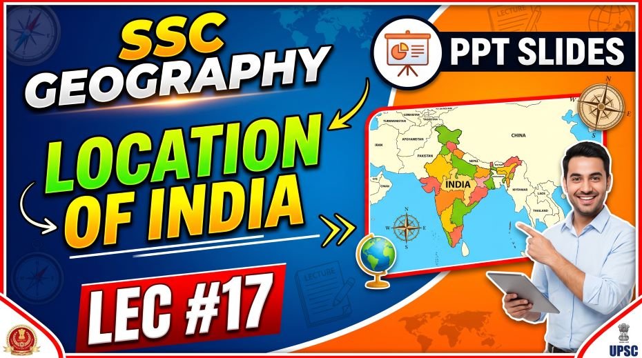
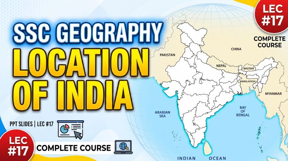
This article accompanies the SSC Geography Location of India PPT Slides (LEC #17) – Serial #96 of the Complete Foundation Batch for All SSC Exams PPT Series on slideshareppt.net. With 112 slides in bilingual Hindi + English format, this lecture covers India’s geography – its location, size, shape, borders, coastline, states, Union Territories, and all associated exam facts – in complete depth aligned to the SSC exam pattern.
India’s geographical location is the starting point of every competitive exam’s Geography syllabus – and rightly so, since questions on India’s position, boundaries, extent, neighbours, coastline, and extreme points appear in virtually every SSC CGL, SSC CHSL, SSC MTS, SSC GD Constable, and RRB Group D paper.
PPT Resource Overview
| Detail | Information |
| Lecture Number | LEC #17 (Geography Series) |
| Serial Number in Complete Batch | #96 |
| Subject | Geography – Location of India (भारत का स्थान) |
| Series Name | Complete Foundation Batch for All SSC Exams (PPT Series) |
| Total Slides | 112 PPT Slides |
| File Size | 35 MB |
| Language | Hindi + English (Bilingual) |
| Format Available | Google Slides & Google Drive (PDF also available) |
| Website | www.slideshareppt.net |
| Target Exams | SSC CGL, SSC CHSL, SSC MTS, SSC GD Constable, RRB Group D |
| Suitable For | Students (self-study & marathon revision) and Teachers (classroom use) |
SSC Geography Location of India PPT Slides (LEC #17)
Note: Above is PPT in GOOGLE SLIDES (HTML AND IFRAME COMBINATION) and if you wish to download the Complete SSC series (PPT slides), visit this Link – REDIRECT PAGE.
Master Timeline: India – Key Political and Geographic Milestones
| Year | Event | SSC Relevance |
| ~3300 BCE | Indus Valley Civilisation – one of the world’s earliest urban civilisations in NW India/Pakistan | Ancient India’s geographic heartland |
| 321–185 BCE | Maurya Empire – first large empire unifying most of the Indian subcontinent; capital at Pataliputra (modern Patna) | First pan-Indian empire |
| 1526–1857 | Mughal Empire – major power across India; capital at Delhi and Agra | Mughal India geography |
| 1600 | British East India Company established | Start of British presence in India |
| 1857 | First War of Independence (Sepoy Mutiny); British Crown takes direct control of India | Shift to British Crown rule |
| 15 August 1947 | India gains independence; Partition creates India and Pakistan | Independence and Partition – most asked date |
| 26 January 1950 | India becomes a Republic; Constitution of India comes into force | Republic Day – constitution adoption |
| 1956 | States Reorganisation Act – states reorganised on linguistic basis; modern state map begins to take shape | State reorganisation – SSC GK |
| 1960 | Bombay State split into Maharashtra and Gujarat | State formation fact |
| 1975 | Sikkim joins India as the 22nd state following a referendum | Sikkim’s accession – frequently asked |
| 2000 | Three new states created: Chhattisgarh (from MP), Uttarakhand (from UP), Jharkhand (from Bihar) | New state formation 2000 |
| 2014 | Telangana formed from Andhra Pradesh – India’s 29th state | Telangana formation – most recently asked |
| 2019 | Jammu & Kashmir reorganised – J&K and Ladakh become two separate Union Territories | J&K bifurcation – very important current affairs |
| Present | India has 28 States and 8 Union Territories | Current count – most asked |
India – Location, Size, and Basic Geographic Facts
India is the seventh-largest country in the world by area and the most populous country since 2023. Located entirely in the Northern Hemisphere and mostly in the Eastern Hemisphere, India occupies the southern portion of Asia, jutting into the Indian Ocean between the Arabian Sea to the west and the Bay of Bengal to the east. The Indian subcontinent’s central peninsular position gives it control over the most important sea lanes in the Indian Ocean, connecting East Asia, the Middle East, Europe, and Africa.
India – Complete Core Facts Table
| Parameter | Detail |
| Official Name | Republic of India (Bharat Ganrajya) |
| Capital | New Delhi |
| Total Area | 32,87,263 sq km – 7th largest country in the world |
| Total Area (approximate) | ~3.287 million sq km |
| World Rank by Area | 7th (after Russia, Canada, USA, China, Brazil, Australia) |
| Population | ~1.44 billion (2023) – most populous country in the world since April 2023 |
| World Rank by Population | 1st (surpassed China in 2023) |
| Location (Hemisphere) | Entirely in the Northern Hemisphere; mostly in the Eastern Hemisphere |
| Latitudinal Extent | 8°4’N (Indira Point, Great Nicobar) to 37°6’N (Indira Col, near Siachen) |
| Longitudinal Extent | 68°7’E (Sir Creek, Gujarat) to 97°25’E (Kibithu, Arunachal Pradesh) |
| North–South Length | 3,214 km |
| East–West Width | 2,933 km |
| Total Land Border | ~15,200 km |
| Total Coastline (including islands) | 7,516.6 km |
| Mainland Coastline | ~5,422 km |
| Standard Time Meridian | 82.5°E longitude – passes through Mirzapur, Uttar Pradesh |
| IST (Indian Standard Time) | GMT + 5 hours 30 minutes |
| Tropic of Cancer | Passes through India at 23.5°N through 8 states |
| Political Division | 28 States + 8 Union Territories |
| Shape comparison | India’s shape roughly resembles a quadrilateral; sometimes compared to a right-angled triangle |
Extreme Points of India – Complete Reference Table
| Direction | Location Name | State / UT | Coordinates | Key SSC Fact |
| Northernmost Point | Indira Col (near Siachen Glacier) | Jammu & Kashmir / Ladakh | ~37°6’N, 76°E | Highest extreme point of India; near the Karakoram Range; Siachen Glacier is nearby |
| Southernmost Point (mainland) | Cape Comorin / Kanyakumari | Tamil Nadu | ~8°4’N | Where the Arabian Sea, Bay of Bengal, and Indian Ocean meet; Vivekananda Rock Memorial nearby |
| Southernmost Point (overall, incl. islands) | Indira Point | Great Nicobar Island (A&N Islands) | ~6°45’N | Actual southernmost tip of India; partially submerged after 2004 Tsunami; named after Indira Gandhi |
| Westernmost Point | Sir Creek (Guhar Moti / Koteshwar) | Gujarat | ~68°7’E | Near the Pakistan border; marshy area; subject of maritime boundary dispute with Pakistan |
| Easternmost Point | Kibithu (Kibithoo) | Arunachal Pradesh | ~97°25’E | Near the border with China and Myanmar; remote area; first place in India to see the sunrise |
India’s Neighbouring Countries – Complete Table
| Country | Border Type | Shared Border Length (approx.) | Location Relative to India | Key SSC Fact |
| Bangladesh | Land | 4,156 km | East and Northeast | Longest land border shared by India; surrounds India’s northeastern states on 3 sides; shares the Ganga-Brahmaputra delta |
| China | Land | 3,488 km | North and Northeast | 2nd longest; disputed boundary (Line of Actual Control – LAC); Galwan Valley incident (2020); Aksai Chin disputed |
| Pakistan | Land | 3,323 km | West and Northwest | 3rd longest; Line of Control (LOC) in J&K; Wagah border (Amritsar); shares Indus river system |
| Nepal | Land | 1,751 km | North (central Himalayas) | Open border – citizens can move freely; Mount Everest on Nepal-China border; shares Terai plain |
| Myanmar | Land | 1,643 km | East | Shares border with Arunachal Pradesh, Nagaland, Manipur, Mizoram; Strategic importance for NE connectivity |
| Bhutan | Land | 699 km | North (eastern Himalayas) | Small landlocked kingdom; India handles Bhutan’s external affairs and defence; close strategic ally |
| Afghanistan | Land | 106 km | Northwest | Very short land border through the Wakhan Corridor (now effectively through Pakistan-administered territory; disputed) |
| Sri Lanka | Sea (Palk Strait) | No land border | South (across Palk Strait) | Separated by Palk Strait (~22 km at narrowest); connected historically through Rama Setu (Adam’s Bridge) sandbar |
| Maldives | Sea (Indian Ocean) | No land border | Southwest (Indian Ocean) | India’s maritime neighbour; smallest Asian country by land area; lowest-lying nation on Earth |
Tropic of Cancer Through India – 8 States
| State | Order (West to East) | Brief Geographic Note |
| Gujarat | 1st | Westernmost state through which Tropic of Cancer passes; near the Rann of Kutch |
| Rajasthan | 2nd | Thar Desert; largest state of India by area |
| Madhya Pradesh | 3rd | Largest state by area after Rajasthan; ‘Heart of India’ |
| Chhattisgarh | 4th | Mineral-rich state; formed from MP in 2000 |
| Jharkhand | 5th | Formed from Bihar in 2000; rich in coal and minerals |
| West Bengal | 6th | Only state bordering Nepal, Bhutan, Bangladesh, and Sikkim; Kolkata is major city |
| Tripura | 7th | Tiny northeastern state; almost completely surrounded by Bangladesh |
| Mizoram | 8th | Easternmost state through which Tropic of Cancer passes; borders Myanmar and Bangladesh |
States and Union Territories of India – Reference Table
India currently has 28 States and 8 Union Territories (after the bifurcation of Jammu & Kashmir into J&K UT and Ladakh UT in October 2019).
| State / UT | Capital | Key Geographic / SSC Fact |
| Andhra Pradesh | Amaravati | Bisected state – bifurcated to form Telangana in 2014; long Eastern coastline; major delta |
| Arunachal Pradesh | Itanagar | Largest state in NE India; easternmost point Kibithu; borders China (disputed – LAC) |
| Assam | Dispur | Brahmaputra Valley; highest tea production; borders Bangladesh, Bhutan, China (through AP), Myanmar |
| Bihar | Patna | Gangetic plain; ancient Pataliputra; birthplace of Buddhism (Bodh Gaya) |
| Chhattisgarh | Raipur | Formed from MP in 2000; mineral-rich (coal, iron, bauxite) |
| Goa | Panaji | Smallest state by area; shortest coastline (~101 km); former Portuguese colony |
| Gujarat | Gandhinagar | Longest coastline (~1,600 km); westernmost extreme point; birthplace of Gandhi; Rann of Kutch |
| Haryana | Chandigarh | Landlocked; shares capital Chandigarh with Punjab; surrounds Delhi on 3 sides |
| Himachal Pradesh | Shimla | Mountain state; Rohtang Pass; Spiti Valley; source of Sutlej, Beas rivers |
| Jharkhand | Ranchi | Formed from Bihar in 2000; Chota Nagpur Plateau; richest mineral state (coal, iron) |
| Karnataka | Bengaluru | IT hub of India; coffee and silk production; Western Ghats; Kaveri river |
| Kerala | Thiruvananthapuram | Highest literacy rate in India; backwaters; spice coast; no land border with any other country except India |
| Madhya Pradesh | Bhopal | Geographical centre of India; ‘Heart of India’; largest producer of soybean |
| Maharashtra | Mumbai | Most industrialised state; largest economy; Mumbai is India’s financial capital |
| Manipur | Imphal | Landlocked NE state; Loktak Lake (largest freshwater lake in NE India); borders Myanmar |
| Meghalaya | Shillong | Wettest state; Mawsynram and Cherrapunji – among world’s highest rainfall; ‘Scotland of the East’ |
| Mizoram | Aizawl | Highest literacy rate after Kerala; borders Myanmar and Bangladesh; bamboo forests |
| Nagaland | Kohima | Battle of Kohima (WW2); Dzükou Valley; borders Myanmar |
| Odisha | Bhubaneswar | Chilika Lake – largest coastal lagoon in India; temple architecture; Olive Ridley turtles |
| Punjab | Chandigarh | Shares capital with Haryana; ‘Land of Five Rivers’; granary of India; Golden Temple at Amritsar |
| Rajasthan | Jaipur | Largest state by area; Thar Desert; Aravalli Range; Sambhar Lake (India’s largest inland salt lake) |
| Sikkim | Gangtok | Smallest state by area in NE; joined India in 1975; borders Nepal, Bhutan, China; Kanchenjunga (3rd highest peak) |
| Tamil Nadu | Chennai | Longest coastline among southern states; Nilgiri Hills; Western & Eastern Ghats junction |
| Telangana | Hyderabad | India’s newest state (2014); formed from AP; Deccan Plateau |
| Tripura | Agartala | Almost entirely surrounded by Bangladesh; smallest mainland NE state |
| Uttar Pradesh | Lucknow | Most populous state; Ganga-Yamuna doab; Prayagraj, Varanasi, Mathura, Agra; most MPs in Lok Sabha |
| Uttarakhand | Dehradun | Formed from UP in 2000; ‘Devbhumi’; sources of Ganga (Gangotri) and Yamuna (Yamunotri) |
| West Bengal | Kolkata | Sundarbans delta; borders Nepal, Bhutan, Bangladesh, Sikkim; jute production |
| Andaman & Nicobar Islands (UT) | Port Blair | Southernmost UT; Indira Point (India’s southernmost tip); Barren Island (only active volcano); Cellular Jail |
| Chandigarh (UT) | Chandigarh | Shared capital of Punjab and Haryana; India’s first planned city |
| Dadra & Nagar Haveli and Daman & Diu (UT) | Daman | Merged UT (2020); former Portuguese and later French colonies |
| Delhi (NCT) | New Delhi | National Capital Territory; no full statehood; seat of Central Government; Yamuna river |
| Jammu & Kashmir (UT) | Srinagar (summer) / Jammu (winter) | Reorganised from J&K state in 2019; with Legislature; has Dal Lake, Wular Lake, Jhelum river |
| Ladakh (UT) | Leh | Without Legislature; India’s largest UT by area; borders Pakistan and China; highest plateau; pangong Lake |
| Lakshadweep (UT) | Kavaratti | Smallest UT by area and population; coral atoll islands; only Muslim-majority UT; in Arabian Sea |
| Puducherry (UT) | Puducherry | Former French colony; has 4 non-contiguous districts; coastal enclave within Tamil Nadu and Andhra Pradesh |
India’s Coastal States and Union Territories
| State / UT | Sea / Ocean | Approximate Coastline | Key Fact |
| Gujarat | Arabian Sea | ~1,600 km | Longest coastline of any Indian state |
| Maharashtra | Arabian Sea | ~720 km | Including Mumbai (India’s financial capital) |
| Goa | Arabian Sea | ~101 km | Shortest coastline of any Indian state |
| Karnataka | Arabian Sea | ~320 km | Malpe Port, Mangaluru Port |
| Kerala | Arabian Sea / Indian Ocean | ~580 km | Kochi (Cochin) – major natural harbour |
| Tamil Nadu | Bay of Bengal / Indian Ocean | ~1,076 km | 2nd longest coastline; multiple major ports |
| Andhra Pradesh | Bay of Bengal | ~974 km | Visakhapatnam – major port |
| Odisha | Bay of Bengal | ~480 km | Paradip Port; Chilika Lake nearby |
| West Bengal | Bay of Bengal | ~158 km | Haldia Port; Sundarbans delta |
| Andaman & Nicobar Islands (UT) | Bay of Bengal / Indian Ocean | ~1,962 km (island perimeter) | India’s largest UT coastline (island perimeter); includes Indira Point |
| Lakshadweep (UT) | Arabian Sea | ~132 km | Coral islands; no harbour accessible by large ships |
| Puducherry (UT) | Bay of Bengal | ~45 km | 4 non-contiguous coastal sections |
| Daman & Diu (part of merged UT) | Arabian Sea | Small | Part of Dadra & Nagar Haveli and Daman & Diu UT |
Landlocked States of India
| State | Neighbouring States / Countries |
| Haryana | Punjab, Himachal Pradesh, Uttarakhand, UP, Rajasthan, Delhi |
| Delhi (NCT) | Haryana and Uttar Pradesh |
| Madhya Pradesh | UP, Chhattisgarh, Maharashtra, Rajasthan, Gujarat |
| Chhattisgarh | MP, Maharashtra, Telangana, Odisha, Jharkhand, UP |
| Jharkhand | Bihar, West Bengal, Odisha, Chhattisgarh, UP |
| Telangana | Maharashtra, Chhattisgarh, Odisha, AP, Karnataka |
| Rajasthan | Pakistan, Gujarat, MP, UP, Haryana, Punjab |
| Sikkim | Nepal, China, Bhutan, West Bengal |
| Manipur | Nagaland, Mizoram, Assam, Myanmar |
| Meghalaya | Assam, Bangladesh |
| Nagaland | Arunachal Pradesh, Assam, Manipur, Myanmar |
| Tripura | Assam, Mizoram, Bangladesh |
| Himachal Pradesh | J&K, Ladakh, Uttarakhand, Punjab, Haryana |
| Uttarakhand | HP, UP, Nepal, China (Tibet) |
Indian States Bordering Neighbouring Countries
| Neighbouring Country | Indian States / UTs on the Border |
| Pakistan | Jammu & Kashmir (UT), Punjab, Rajasthan, Gujarat |
| China | Ladakh (UT), Himachal Pradesh, Uttarakhand, Sikkim, Arunachal Pradesh |
| Nepal | Uttarakhand, UP, Bihar, West Bengal, Sikkim |
| Bhutan | Sikkim, West Bengal, Assam, Arunachal Pradesh |
| Bangladesh | West Bengal, Assam, Meghalaya, Tripura, Mizoram |
| Myanmar | Arunachal Pradesh, Nagaland, Manipur, Mizoram |
| Sri Lanka | Tamil Nadu (sea border across Palk Strait) |
Quick Fact Table – Location of India for SSC Exams
| Question / Fact | Answer |
| India’s total area | 32,87,263 sq km |
| India’s rank by area | 7th largest country in the world |
| India’s rank by population (2023) | 1st (most populous country; surpassed China in 2023) |
| Latitudinal extent | 8°4’N to 37°6’N |
| Longitudinal extent | 68°7’E to 97°25’E |
| North-South length | 3,214 km |
| East-West width | 2,933 km |
| Total land border length | ~15,200 km |
| Total coastline (with islands) | 7,516.6 km |
| Longest land border (with which country?) | Bangladesh – 4,156 km |
| Shortest land border (with which country?) | Afghanistan – 106 km |
| India’s northernmost point | Indira Col, near Siachen Glacier (J&K/Ladakh) – ~37°6’N |
| India’s southernmost point (overall) | Indira Point, Great Nicobar Island – ~6°45’N |
| India’s southernmost point (mainland) | Cape Comorin / Kanyakumari, Tamil Nadu |
| India’s westernmost point | Sir Creek (Guhar Moti), Gujarat – ~68°7’E |
| India’s easternmost point | Kibithu, Arunachal Pradesh – ~97°25’E |
| Standard Time Meridian | 82.5°E – Mirzapur, Uttar Pradesh |
| IST | GMT + 5 hours 30 minutes |
| Tropic of Cancer passes through | 8 Indian states – Gujarat, Rajasthan, MP, Chhattisgarh, Jharkhand, West Bengal, Tripura, Mizoram |
| Total number of States in India | 28 States |
| Total number of Union Territories | 8 Union Territories |
| Largest state by area | Rajasthan (~342,239 sq km) |
| Smallest state by area | Goa (~3,702 sq km) |
| Most populous state | Uttar Pradesh |
| Least populous state | Sikkim |
| State with longest coastline | Gujarat (~1,600 km) |
| State with shortest coastline | Goa (~101 km) |
| Largest UT by area | Ladakh |
| Smallest UT by area and population | Lakshadweep |
| India’s newest state | Telangana (formed 2014 from Andhra Pradesh) |
| Sikkim joined India as the ___ state | 22nd state (1975) |
| States formed in 2000 | Chhattisgarh (from MP), Uttarakhand (from UP), Jharkhand (from Bihar) |
| J&K bifurcated in which year? | 2019 – into J&K (UT with Legislature) and Ladakh (UT without Legislature) |
also read: SSC Geography Rotation of Earth PPT Slides (LEC #16)
Q&A:
Q1: Why is India’s geographical position strategically important?
India occupies one of the most strategically valuable positions on Earth – the Indian subcontinent juts southward into the Indian Ocean, dividing it into the Arabian Sea to the west and the Bay of Bengal to the east. This central position places India along the most important maritime trade routes connecting East Asia, Southeast Asia, the Middle East, East Africa, and Europe. Approximately 80% of the world’s maritime oil trade passes through the Indian Ocean, much of it through straits like Hormuz and Malacca where India’s geographic position gives it monitoring and strategic relevance. India’s island territories – the Andaman & Nicobar Islands near the Malacca Strait and the Lakshadweep Islands in the Arabian Sea – further extend this strategic reach.
Q2: What is the significance of the Tropic of Cancer passing through 8 Indian states?
The Tropic of Cancer at 23.5°N bisects India roughly through its middle, dividing the country into the tropical zone to the south and the subtropical zone to the north. Its passage through 8 states – Gujarat, Rajasthan, Madhya Pradesh, Chhattisgarh, Jharkhand, West Bengal, Tripura, and Mizoram – has practical implications: the southern states experience a true tropical climate with high temperatures year-round, while northern states experience more pronounced seasonal variation. The Tropic of Cancer also determines the timing of the overhead Sun – it is directly overhead on June 21 (Summer Solstice) over all points at 23.5°N, which includes parts of these 8 states.
India’s longest land border (4,156 km) is with Bangladesh, which is geographically unusual given that Bangladesh is a relatively small country. This long border length exists because of the extremely complex and irregular boundary that was drawn during the 1947 Partition, which created many enclaves, exclaves, and non-contiguous sections. Bangladesh is effectively enclosed on three sides by India – northeast India (Assam, Meghalaya, Tripura, Mizoram) wraps around Bangladesh, and West Bengal borders it on the west. The boundary follows rivers, administrative lines, and the patchwork of partitioned districts in Bengal, resulting in a highly convoluted and lengthy borderline despite Bangladesh’s relatively compact size.
Q4: What happened to Jammu & Kashmir in 2019 and what are the current UTs?
In August 2019, the Indian government revoked the special status of the erstwhile state of Jammu & Kashmir under Article 370 and Article 35A of the Constitution, and simultaneously bifurcated it into two Union Territories. Jammu & Kashmir (J&K) became a UT with a Legislature – meaning it has its own elected legislative assembly and Chief Minister, similar to Delhi and Puducherry. Ladakh became a UT without a Legislature – governed directly by the Centre through a Lieutenant Governor, making it comparable to Chandigarh and Lakshadweep. This reduced India’s total state count from 29 to 28, while increasing the UT count from 7 to 8. Ladakh is now India’s largest UT by area.
Q5: Why is the difference between India’s northernmost and southernmost points important for SSC exams?
India’s northernmost point is Indira Col near the Siachen Glacier at approximately 37°6’N, while the true southernmost point is Indira Point on Great Nicobar Island at approximately 6°45’N – a difference of over 30 degrees of latitude, corresponding to roughly 3,214 km from north to south on the mainland. This distinction is frequently tested in SSC exams because students confuse Kanyakumari (Cape Comorin) with India’s southernmost point – Kanyakumari is the southernmost point of mainland India, while Indira Point on Great Nicobar Island is India’s actual southernmost tip. Indira Point is further notable because it was partially submerged during the 2004 Indian Ocean Tsunami.
Q6: How does India’s longitudinal extent create practical time differences?
India spans approximately 68.7°E to 97.25°E – a difference of about 28.5° of longitude. Since every 1° of longitude equals 4 minutes of time difference, the natural time difference between India’s easternmost point (Kibithu, Arunachal Pradesh) and westernmost point (Sir Creek, Gujarat) is approximately 28.5 × 4 = 114 minutes, or nearly 2 hours. Despite this natural variation, India maintains a single IST (GMT + 5:30) for the entire country for administrative simplicity. As a result, Arunachal Pradesh and Assam experience sunrise about 1.5–2 hours earlier than Gujarat and Rajasthan by the clock – a frequently discussed geographical implication of India’s wide longitudinal extent.
Q7: Which Indian states border the maximum number of other states?
Uttar Pradesh borders the most Indian states – it shares boundaries with 8 other states and 1 Union Territory: Uttarakhand, Himachal Pradesh (small section), Delhi (NCT), Haryana, Rajasthan, Madhya Pradesh, Chhattisgarh, Bihar, and Jharkhand, plus the international borders with Nepal. Madhya Pradesh comes next, sharing borders with 5 states: UP, Chhattisgarh, Maharashtra, Rajasthan, and Gujarat. These multi-border facts are commonly tested in SSC exams, especially questions like ‘which state borders the most states’ or ‘which state is surrounded by the most neighbours.’
Rapid Revision Cheat Sheet – Location of India
| Topic | Key Point |
| India’s area | 32,87,263 sq km – 7th largest country |
| India’s population rank | 1st (2023 onward – surpassed China) |
| Latitudinal extent | 8°4’N to 37°6’N |
| Longitudinal extent | 68°7’E to 97°25’E |
| N-S length / E-W width | 3,214 km / 2,933 km |
| Land border total | ~15,200 km |
| Coastline (with islands) | 7,516.6 km |
| Longest land border | Bangladesh – 4,156 km |
| Shortest land border | Afghanistan – 106 km |
| Northernmost point | Indira Col, near Siachen (~37°6’N) |
| Southernmost (overall) | Indira Point, Great Nicobar Island (~6°45’N) |
| Southernmost (mainland) | Cape Comorin / Kanyakumari, Tamil Nadu |
| Westernmost point | Sir Creek, Gujarat (~68°7’E) |
| Easternmost point | Kibithu, Arunachal Pradesh (~97°25’E) |
| IST meridian | 82.5°E – Mirzapur, UP – GMT + 5:30 |
| Tropic of Cancer (8 states) | Gujarat, Rajasthan, MP, Chhattisgarh, Jharkhand, West Bengal, Tripura, Mizoram |
| States / UTs | 28 States + 8 Union Territories |
| Largest state by area | Rajasthan |
| Smallest state by area | Goa |
| Most populous state | Uttar Pradesh |
| Least populous state | Sikkim |
| Longest coastline state | Gujarat (~1,600 km) |
| Shortest coastline state | Goa (~101 km) |
| Largest UT by area | Ladakh |
| Smallest UT | Lakshadweep |
| Newest state | Telangana (2014) |
| States formed in 2000 | Chhattisgarh, Uttarakhand, Jharkhand |
| J&K bifurcated | 2019 – J&K UT (with Legislature) + Ladakh UT (without Legislature) |
| Sea neighbours | Sri Lanka (Palk Strait) and Maldives (Indian Ocean) |
| Serial number of this PPT | #96 in the Complete Foundation Batch |
Conclusion
Location of India is the gateway topic for all Indian Geography preparation – and one where every fact is directly testable with no ambiguity. India’s area, extreme points, neighbouring countries and their border lengths, coastline state rankings, the Tropic of Cancer’s 8-state passage, and the count of states and UTs are among the most reliably asked facts in every SSC and RRB paper.
The SSC Geography Location of India PPT Slides (LEC #17), Serial #96, available at slideshareppt.net in bilingual Hindi + English format across 112 slides, gives you the complete visual companion for this topic. Memorise the extreme points, master the neighbour-border table, and keep the Rapid Revision Cheat Sheet close in your final week. This topic is one of the easiest 3–5 marks you can earn in any SSC or RRB exam with systematic preparation.