Drainage System of India UPSC Notes Pdf Download
Contents
Today we will share the Complete Notes related to the Drainage System of India UPSC Notes PDF Download (Complete UPSC PPT SLIDES), India boasts a diverse and intricate drainage system that plays a crucial role in shaping its geographical and ecological features. This extensive network of rivers and their tributaries not only sustains life by providing water for various purposes but also influences the country’s landscape, agriculture, and overall development. Let’s delve into the intricacies of the drainage system of India.
Drainage System of India UPSC Notes Pdf Download
(Lec 13)
Note:-
- If you are viewing this PPT on your phone, please make it full screen and then view it. (Press: 3 dots in PPT, then Full Screen)
- If you have a problem while clicking on next, (Just tap) on the slide instead of clicking Next Botton
- FOR A BETTER VIEW PRESS Ctrl + Shift + F ON A PC OR LAPTOP.
- Whatever is written in the PPT is different and whatever is written below is different.
UPSC Prelims PPT Bundle Product Details
(BUY ONLINE)
| Placement / Section | Details / Click To Action Text |
|---|---|
| Title | UPSC Prelims PPT Notes (BUNDLE) |
| Number of PPTs / Slides | 160+ PPTs |
| Delivery Method | Instant Access after Payment (Google Drive Folder) |
| Additional Info | Full UPSC Prelims Coverage, Study-Friendly PPT Format |
| Copyright / Ownership | Self-made Notes (slideshareppt.net) |
| Payment | Online Gateway – QR, CREDIT CARD, UPI etc… |
| Pricing / Purchase CTA |
Check Price & Buy (Redirects to Pricing Page) |
| Demo Link | View Sample Slides (Click to Open Demo) |
Understanding the Drainage System of India: Exploring Basins, Patterns, and River Systems
India’s drainage system is a complex network that plays a crucial role in shaping the country’s landscape and supporting its diverse ecosystems. This article explores the drainage basins, patterns, and major river systems that define India’s hydrological landscape.
Drainage Basin and Patterns
- Drainage Basin: The total area contributing water to a single drainage system is known as a drainage basin. It serves as the fundamental unit for understanding the flow of water in a region.
- Drainage Pattern: The geometric design formed by a river and its tributaries from source to mouth defines the drainage pattern. Various patterns include dendritic, trellised, rectangular, radial, centripetal, annular, parallel, barbed, and pinnate.
Here is the table:
| Drainage Pattern | Description |
|---|---|
| Dendritic Drainage Pattern | Resembles the branches of a tree; widespread and random distribution of tributaries. |
| Trellised Drainage Pattern | Resembles a pattern of a checkerboard; tributaries join at right angles, forming a grid-like network. |
| Rectangular Drainage Pattern | Forms a pattern of rectangles or squares; tributaries meet at right angles, creating a rectangular grid. |
| Radial Drainage Pattern | Radiates outward from a central point; tributaries flow outward in all directions from a central highland or peak. |
| Centripetal Drainage Pattern | Flows toward a central point; tributaries converge and flow towards a central basin or depression. |
| Annular Drainage System | Forms a circular pattern; common around structural domes or basins, creating circular drainage paths. |
| Parallel Drainage Pattern | Flows parallel to each other; several streams run parallel, often found in regions with parallel geological structures. |
| Barbed Drainage Pattern | Resembles a fish’s skeleton; tributaries join the main river at acute angles, giving a barbed appearance. |
| Pinnate Drainage Pattern | Resembles the veins of a feather; tributaries join the main river in a pattern resembling the arrangement of feather veins. |
This table provides a comprehensive overview of various drainage patterns found in the rivers of India, along with descriptions to help understand the characteristics of each pattern.
River Basins of India
Large, Medium, and Minor River Basins: India’s river systems are categorized into large, medium, and minor basins, each contributing to the overall drainage network.
Here is the table:
| River Basin Size | Description | Examples |
|---|---|---|
| Large River Basin | Extensive drainage area contributing to major rivers. | Ganga River Basin, Brahmaputra River Basin |
| Medium River Basin | Moderate-sized drainage area with significant rivers. | Yamuna River Basin, Godavari River Basin |
| Minor River Basin | Relatively smaller drainage area with minor rivers. | Ken River Basin, Damodar River Basin |
This table provides a categorization of river basins in India based on their size, with examples of major rivers associated with each basin size category.
Major River Systems
Himalayan Rivers:
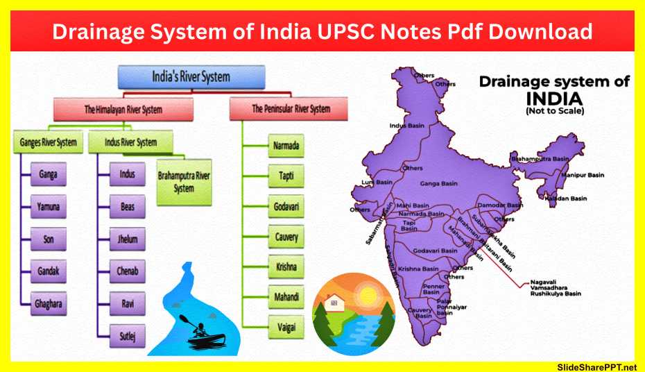
- Indus River System: Comprising tributaries like Jhelum, Chenab, Ravi, Beas, and Sutlej, the Indus system is vital for northern India.
- Ganga River System: With origins in the Gangotri glacier, the Ganga system includes the Yamuna, Alaknanda, Bhagirathi, and others.
- Brahmaputra River System: Originating in Tibet, the Brahmaputra flows through India, contributing to the northeastern drainage.
Peninsular Rivers:
- Mahanadi, Godavari, Krishna, Kaveri, Narmada, Tapti: These rivers form the Peninsular drainage system, serving regions in the southern part of the country.
- Chambal, Sindh, Betwa & Ken, Damodar, Ramaganga, Ghaghara, Saryu, Gandak, Kosi: These rivers further contribute to the complex network, impacting the central and northern regions.
Here is the table.
| Major River System | Subsystem / Tributaries | Main Features |
|---|---|---|
| Himalayan Rivers | Indus River System | Jhelum, Chenab, Ravi, Beas, Satluj |
| Ganga River System | Panch Prayag, Alaknanda, Satopanth Glacier, Dhauliganga, Nandakini, Pindar Ganga, Mandakini, Bhagirathi | |
| Brahmaputra River System | Flows through Tibet, India, and Bangladesh | |
| Peninsular Rivers | Mahanadi River System | Mahanadi, Tel, Ib, Jonk |
| Godavari River System | Godavari, Indravati, Manjira, Pranhita | |
| Krishna River System | Krishna, Tungabhadra, Bhima, Musi | |
| Kaveri River System | Kaveri, Kabini, Hemavati, Shimsha | |
| Narmada River System | Narmada, Tawa, Barna, Kolar | |
| Tapti River System | Tapti, Purna, Panzara, Girna |
This comprehensive table provides information on the major river systems in India, categorizing them into Himalayan and Peninsular rivers, and further detailing their subsystems and significant tributaries.
Himalayan River System table
| Himalayan River System | Subsystem / Tributaries | Main Features |
|---|---|---|
| Indus River System | Jhelum, Chenab, Ravi, Beas, Satluj | Flows through parts of India and Pakistan |
| Ganga River System | Panch Prayag, Alaknanda, Satopanth Glacier, Dhauliganga, Nandakini, Pindar Ganga, Mandakini, Bhagirathi | Flows through the northern plains of India |
| Yamuna River System | Yamunotri Glacier, Banderpunch Range | A major tributary of the Ganga River |
This informative table provides details on the Himalayan River System, highlighting its subsystems (Indus, Ganga, and Yamuna) along with their tributaries and main features.
Table of River System.
| River System | Main Features |
|---|---|
| Chambal River | A tributary of the Yamuna River, flowing through Rajasthan and Madhya Pradesh. Known for its wildlife and ravines. |
| Sindh River | Flows through the northern region of India, serving as a tributary of the Indus River. |
| Betwa & Ken River System | Major rivers in central India, flowing through Madhya Pradesh and Uttar Pradesh. |
| Damodar River System | Known as the “Sorrow of Bengal” due to frequent floods and its role in the Damodar Valley Corporation. |
| Ramganga River System | A tributary of the Ganga River, flowing through Uttarakhand and Uttar Pradesh. Known for Jim Corbett National Park. |
| Ghaghara River System | One of the major tributaries of the Ganga River originates in Tibet and flows through Nepal and India. |
| Saryu River System | Flows through northern India, originating in the Himalayas and joining the Ghaghara River. |
| Gandak River System | A major tributary of the Ganga River, originating in Nepal and flowing through northern India. |
| Kosi River System | Known as the “Sorrow of Bihar” due to its history of causing devastating floods. Originates in Nepal. |
| Brahmaputra River System | A transboundary river flowing through Tibet, India, and Bangladesh. Known for its vast basin and diverse ecosystems. |
This modified table provides information on various river systems, removing the column for subsystems/tributaries and focusing on the main features of each river system.

Evolution of Peninsular Drainage System
- Water Divide: The division between rivers flowing eastward and westward in the peninsular region is known as the water divide.
- Mahanadi, Godavari, Krishna, Cauvery: These rivers, forming rift valleys, create a distinct drainage pattern in peninsular India.
- Narmada and Tapi: These rivers flow through faults, contributing to the unique characteristics of the peninsular drainage.
Here is the table.
| Peninsular River System | Description |
|---|---|
| Evolution of Peninsular Drainage System | Describes the historical development and formation of the peninsular drainage network. |
| The Water Divide | Refers to the division between rivers flowing eastward and westward in the peninsular region. |
| Mahanadi River System | The major river system on the east coast includes the Mahanadi River and its tributaries. |
| Godavari River System | One of the largest river systems flows eastward and drains into the Bay of Bengal. |
| Krishna River System | Flows eastward and empties into the Bay of Bengal, with significant agricultural importance. |
| Cauvery River | Flows through the southern part of the peninsula, providing water for agriculture and human consumption. |
| Rift Valley Rivers | Describes rivers that flow through rift valleys, influencing the peninsular drainage pattern. |
| Narmada River | Flows westward and drains into the Arabian Sea, forming a distinct rift valley. |
| Tapi River | Another west-flowing river, parallel to the Narmada, drains into the Arabian Sea. |
| Luni River | Drains into the Rann of Kutch, known for its intermittent flow and saline nature. |
| Sabarmati | Flows through Gujarat, drains into the Arabian Sea, and is known for the Sabarmati Ashram associated with Mahatma Gandhi. |
| Mahi River | Drains into the Arabian Sea, passing through the states of Madhya Pradesh, Rajasthan, and Gujarat. |
This informative table provides details on various components of the Peninsular River System, including the evolution of the drainage system, water divide, and individual river systems such as Mahanadi, Godavari, Krishna, Cauvery, Narmada, Tapi, Luni, Sabarmati, and Mahi.
Key Differences Between Himalayan and Peninsular Rivers
- Himalayan rivers are perennial, fed by snowmelt, while peninsular rivers are often seasonal.
- The drainage patterns and geological features vary between the two regions.
- The Himalayan rivers have a greater discharge and are significant for the fertile plains they traverse.
Here is the table.
| Key Differences Between Himalayan and Peninsular Rivers | Description | Example |
|---|---|---|
| Geographical Origin | Himalayan Rivers: Originate in the Himalayan mountain range. Examples include Ganga, Brahmaputra, and Indus. | Ganga River System |
| Peninsular Rivers: Originate within the peninsular plateau, away from the Himalayas. Examples include Godavari, Krishna, and Cauvery. | Godavari River System | |
| Type of Terrain | Himalayan Rivers: Flow through rugged mountainous terrain, resulting in steep gradients and turbulent flow. | Indus River through the Himalayas |
| Peninsular Rivers: Flow through relatively flat and stable peninsular plateaus, leading to a more gentle flow. | Godavari River through the Deccan Plateau | |
| Source of Water | Himalayan Rivers: Primarily fed by snowmelt and glaciers, ensuring a perennial water supply. | Brahmaputra River fed by Tibetan glaciers |
| Peninsular Rivers: Reliant on rainfall and are often seasonal, experiencing fluctuations in water levels. | Cauvery River dependent on monsoon rains | |
| Discharge | Himalayan Rivers: Generally, higher discharge due to the continuous water supply from melting snow and glaciers. | Ganga River with a consistent flow |
| Peninsular Rivers: Lower discharge, influenced by seasonal rainfall patterns. | Krishna River with seasonal variations | |
| River Course | Himalayan Rivers: Follow a more winding and meandering course due to the challenging mountainous terrain. | Brahmaputra River’s meandering path |
| Peninsular Rivers: Tend to have a more straight and direct course as they flow through flatter terrains. | Godavari River’s relatively straight path | |
| Tributaries | Himalayan Rivers: Often have numerous tributaries originating from the Himalayan region. | Yamuna, Son, and Gandak joining the Ganga |
| Peninsular Rivers: Have fewer and shorter tributaries, originating within the peninsular plateau. | Bhima and Tungabhadra joining the Krishna | |
| Erosional and Depositional Activity | Himalayan Rivers: Exhibit significant erosional activity, transporting large amounts of sediment downstream. | Indus River eroding and carrying sediment |
| Peninsular Rivers: Tend to deposit sediment as they flow, resulting in the formation of river deltas. | Godavari River depositing sediment in the delta | |
| Human Utilization | Himalayan Rivers: Major sources of water for agriculture and settlements in the northern plains. | Ganga River supports agriculture in the Gangetic plains |
| Peninsular Rivers: Support agriculture and are essential for the livelihoods of people in peninsular regions. | Krishna River vital for agriculture in the Deccan Plateau |
This informative table outlines key differences between Himalayan and Peninsular Rivers, including detailed descriptions and examples illustrating each distinction.
In conclusion.
- India’s drainage system is a dynamic and intricate network that sustains the country’s ecosystems and supports various human activities. Understanding these patterns and river systems is crucial for effective water resource management and sustainable development.
- The drainage system of India is a dynamic and complex network that sustains life and influences the country’s physical and cultural aspects. It is crucial for agriculture, human settlement, and overall ecological balance. Understanding this intricate system is vital for effective water resource management, sustainable development, and environmental conservation in the diverse and vast landscape of India.
Also Read: Water in the Atmosphere PPT Download


